


To map Egypt, the British began to map what was not Egypt. Here, villages were divided, and imaginaries were created. But how did Rafah come into play as the final point – and when did we begin to treat this division as reality?

Two soldiers stand under an olive tree in a deserted area. This image, titled “Ancient Boundary Line at Rafah”, was taken in 1898 to indicate what the border between Egypt and Palestine looked like on the ground.1 This image, which enhances the Orientalist perception of an empty, deserted land, acts as a warning to the upcoming violence. Importantly, while the tree stands in a deserted area, the space also presents a continuous image.The border drawn on this land was to be reshaped repeatedly due to British and Ottoman tensions until 1906, when it formed into the separation that is known today. Yet, because of familial connections, anti-colonial regimes, and large popular support for Palestine in Egypt, the border has never been understood to fully function as a border and has, instead, only been referred to as a “crossing”.
Linguistic Games
First, there is an important distinction to be made between the English and Arabic perceptions of the apparatus separating Rafah. In English, Egypt ends at the border, ḥadd, with Gaza. In Arabic, Egypt ends at the crossing, the ma ’bar, with Gaza. This particular distinction serves an ideological purpose: it softens the role of the Egyptian government in the developments of violence in Gaza, and it places the border/zone/crossing between Egypt and Palestine as one that is understood to be porous, one that is perpetually fluid. The term “ma ’bar” itself stems from the root ‘abar, which means “crossed”, with the added “m” serving to perpetuate a permanent ability to cross. The nomenclature entails and alludes to a fluidity and a breathability of the apparatus, even when in reality, the crossing itself often functions as a ḥadd, which, in Arabic, can translate to limit, point, border, or sharpness – the last line to be crossed before you exit Egypt and move into Palestine. There is a permanence in the word “ḥadd”, a breakability that is not ascribed to the fluidity of the other term. It is here that the dissonance between nomenclature and reality begins. While Egyptians continue to perceive Rafah as an unshaped, open plot of land from which entry and exit runs smooth unless otherwise planned for, this ma’bar includes little to no ‘abereen, crossers. In fact, in reality, Rafah serves as more than a simple border/crossing/zone – Rafah, as it has been used, serves as a weapon. It has been a central point of contention in Egyptian politics and relationships to the imperial core even prior to the conception of the Zionist state.
Bordering Egypt
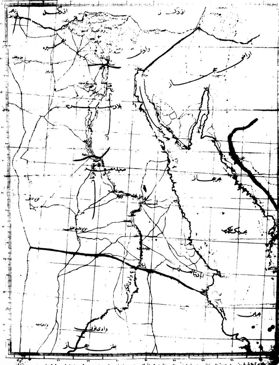
Modern Egyptian borders were created with Ottoman Rule. What is believed to be the first map of Modern Egypt dates back to 1841 and shows the area of land given to Mohammad Ali.2 In this map, it is interesting to note three points of interest: first, the entire area of Sinai is labeled as in the Hijaz, second is that there is a strong border with Sudan that hints to Sudan not being under Ali’s rule despite, and the final is that Rafah remains the final destination in Egypt before the line is drawn.3
When the British occupied Egypt in 1882, tensions arose about the Ottoman-drawn borders. In 1906, the British officially refused the Ottoman boundaries west of the Aqaba-Rafah line, in order to guarantee British control over Sinai.4 During this time, the Ottomans suggested dividing Sinai or other means of keeping control of the South-Eastern boundaries as part of the Hijaz region. All of these possibilities were denied by the British “because any one of them might have endangered the defense of the Suez Canal,”5 in Sinai’s North-West. Thus, “the Rafa-Akaba line was not arbitrarily chosen, but rather a line rooted in the history of the region which best served the British policymakers.”6 From this understanding of British-Egyptian relations comes the understanding of British-Egyptian alliances.
Before the complete independence of Egypt from the British, the subject of the settler colonization of Palestine began being raised in Arab League and independent government meetings. This colonization, discussed since the nineteenth century, gained increasing attention and concern. Notably, the Arab League became an important forum in which these conversations were facilitated. By 1945, Saudi and Iraqi officials began pressuring Arab states to send their armies into Palestine lest an invasion occur.7 Importantly, in 1945, then-Prime Minister Ismail Sidqi declared that he was a “businessman” working for Egypt alone.8This line of discussion continued through 1947, where Mahmoud El Nuqrashi, Egypt’s head of delegation to the UN Security Council, stated that “the Egyptian army would not intervene in Palestine because it was needed to defend Egypt from possible British aggression, and because the Egyptian question was still technically on the UN agenda” but Egypt could send aid to those who volunteer to fight in Palestine.9 Nuqrashi was forced to resign in 1946 as anti-British demonstrations continued to grow, but then regained his position later that year. Indeed, Egypt was working towards its national demands, including the removal of the British military from Egypt and the evacuation of foreign forces from the Suez Canal.10
(In)Dependence, Liberation?
It is, as such, compelling to note a change in Egypt’s rhetoric and actions taken in 1948. Egypt’s invasion of Palestine on May 15, 1948, Nakba Day, was a shock to politicians, diplomats, and high-ranking military commanders alike.11 To this day, many disagree on the reasoning behind this change in rhetoric. Some argued that it was led by rising anger amongst Egyptian support for Palestine, while others pushed the idea that the British may have pushed the Egyptian prime minister to act. Particularly, the Wafd party, the Young Egypt movement, and the Muslim Brotherhood were the leading sources of public pressure, given that the Free Officers Movement, which would eventually topple the monarchy, was pushed to operate secretly during that period.12
It is clear what the popular opinion was during that period. In 1952, President Gamal Abdel Nasser’s memoirs, he recalls his excitement to be sent to fight in Palestine on the 16th of May in 1948, alongside the anticipation of his friends in other battalions.13 During this time, Egypt gained a narrow coastal strip that became home for 200,000 refugees from other parts of Palestine – the Gaza Strip, which it held for two decades.14 Within these two decades, Egypt witnessed independence and a massive shift in its national political rhetoric.
However, with the 1967 and 1973 wars, and the death of Gamal Abdel Nasser, the Pan-Arabist, anti-colonial Egyptian mission died. Even in 1971, Anwar el Sadat, Nasser’s successor, refused to normalize with either the United States or Israel, stating that the US’s choice to support Israel defines its position as hostile against the entire Arab nation.15 However, with the occupation of Sinai and the war against Israel, state politics began to change as Egypt slowly accepted more aid from the US in a bid to regain control over Sinai and Egyptian borders. After 1973, Egypt was instead to welcome the soft encroachment of neoliberalism and normalization – official state policies alongside the new politics of the Egyptian-Israeli treaty of 1979. Slowly, Rafah loses its pores – with each incoming year, the lines drawn on the map begin to truly function as barriers as opposed to the possible flexibility of the pre-’73 geopolitical dynamics.
Thus, the establishment of Rafah as a border city has placed it in a position of perpetual instability. It has never been truly Egyptian as it has always existed in between two states, with families extending before the establishment of the borders that have aimed only to divide what is otherwise united. Importantly, in Egypt, Rafah is still not referred to as a border. It is instead referred to as a crossing, highlighting the perceived continued permeability and acceptance, to some extent, of the pores of the border, regardless of established physical and colonial realities.
Sources
- Library of Congress, Washington, D.C. 20540 USA. “Ancient Boundary Line at Raffah, between Egypt and Palestine.” Image. Accessed November 19, 2023. https://www.loc.gov/item/2019698681/.
- Biger, Gideon. “The First Map of Modern Egypt Mohammed Ali’s Firman and the Map of 1841.” Middle Eastern Studies 14, no. 3 (1978): 323–25.
- Which would further upset the British, who maintained rule over Sudan for decades after the end of the Ottoman Empire.
- Gil-Har, Yitzhak. “Egypt’s North-Eastern Boundary in Sinai.” Middle Eastern Studies 29, no. 1 (1993): 135–48.
- Ibid: 142.
- Ibid: 144.
- Mayer, Thomas. “Egypt’s 1948 Invasion of Palestine.” Middle Eastern Studies 22, no. 1 (1986): 20–36.
- Ibid: 24.
- Ibid: 22.
- Eppel, Michael. “The Arab States and the 1948 War in Palestine: The Socio-Political Struggles, the Compelling Nationalist Discourse and the Regional Context of Involvement.” Middle Eastern Studies 48, no. 1 (2012): 1–31.
- Mayer, Thomas. “Egypt’s 1948 Invasion of Palestine.” Middle Eastern Studies 22, no. 1 (1986): 20–36.
- Eppel, Michael. “The Arab States and the 1948 War in Palestine: The Socio-Political Struggles, the Compelling Nationalist Discourse and the Regional Context of Involvement.” Middle Eastern Studies 48, no. 1 (2012): 1–31.
- Nasser, Gamal Abdul, and Walid Khalidi. “Nasser’s Memoirs of the First Palestine War.” Journal of Palestine Studies 2, no. 2 (1973): 3–32. https://doi.org/10.2307/2535478.
- Reuters. “A Brief History of Gaza’s Centuries of War.” October 13, 2023, sec. Middle East. https://www.reuters.com/world/middle-east/brief-history-gazas-centuries-war-2023-10-13/.
- El Sadat, Anwar. “Statement to the Nation by President Anwar El Sadat.Pdf,” June 1971. https://sadat.umd.edu/sites/sadat.umd.edu/files/Statement%20to%20the%20Nation%20by%20President%20Anwar%20El%20Sadat.PDF.
