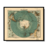
This Kharita™ by August Petermann was published towards the end of the the Golden Age of Antarctic exploration, which was marked by the second wave of national expeditions from a plethora of European nations and Japan.
The map is written in German, the title reads “Süd-Polar-Karte” which translates to south polar map.
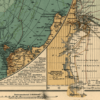
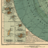
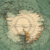
Also shown are the significant explorer’s tracks from, together with the important shipping routes of the South Seas and the iceberg fields. Surrounding this map are 16 smaller maps with the various islands located near the supposed Antarctic continent. Coloured in are the discoveries achieved by each country, with German in red, British in pink, Russian in green, Belgian and Dutch in orange, French in brown, Swedish and Norwegian in grey and American in light green. Marked clearly are Scott’s furthest south in December 1902 during the Discovery Expedition, Shackleton’s furthest south in January 1909 during the British Antarctic Expedition, Amundsen and Scott reaching the South Pole in December 1911 and January 1912 respectively and Filchner’s landing point on the Antarctic coast in the Weddell Sea in 1912.
Map Info
Creator: August Petermann
Date: 1912
Language(s): German
Scale: 1:40,000,000
Location: Antarctica
✪ Heavyweight matte paper at 150 g/sqm
✪ Frame not included
✪ Package comes with shipping tube
NOTICE: International Shipping Temporarily On Hold.
After you place an order, you will receive an email confirming that we have received your order and are processing it. Orders usually take 2–12 business days to arrive.
We do not offer refunds on our maps as they are printed per order. You may request an exchange within 30 days if the item is in good condition.
Visit our Shipping & Returns page for more details.
 Skip to content