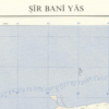
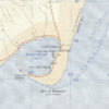
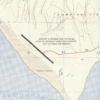
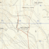
This Kharita™ was compiled and drawn by the royal engineers of the Great British War Office in 1969 from air photography. The map shows the Islands’ roads, builduings, tracks, corals dune and more. It also indicates the direction of true north in relation to magnetic and grid north.
Sir Bani Yas Island is part of the Al Gharbia region of the United Arab Emirates. It’s dominated by the Arabian Wildlife Park, with its roaming giraffes, cheetahs and gazelles. Multiple archaeological sites across the island include the ruins of an ancient Christian monastery. Salt dome hills define the island’s desert interior. The coast features beaches, sea kayak routes and a shipwreck.
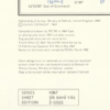
Map Info
Creator: Great British War Office
Date: 1969
Language(s): English
Scale: 1:25,000
Location: Şīr Banī Yās, United Arab Emirates
✪ Heavyweight matte paper at 150 g/sqm
✪ Frame not included
✪ Package comes with shipping tube
NOTICE: International Shipping Temporarily On Hold.
After you place an order, you will receive an email confirming that we have received your order and are processing it. Orders usually take 2–12 business days to arrive.
We do not offer refunds on our maps as they are printed per order. You may request an exchange within 30 days if the item is in good condition.
Visit our Shipping & Returns page for more details.
 Skip to content