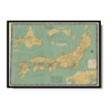
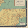
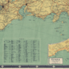
This Kharita™, created by Nihon Kōtsū Kōsha in the mid 20th century served as a tourist map for Japan.
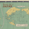
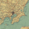
4 inset maps show Hokaido, Osaka, Tokyo and a world map showing airlines routes.
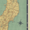
Map also shows national and private railway lines, national and prefectural highways, prefectural boundaries, national parks, steamship lines, longitude and latitude, rivers and lakes, mountains, hot springs, metropolises, prefectural capitals, cities, and towns and villages.
Map Info
Creator: Nihon Kōtsū Kōsha
Date: 1950
Language(s): English
Scale: 1:1,500,000
Location: Japan
✪ Heavyweight matte paper at 150 g/sqm
✪ Frame not included
✪ Package comes with shipping tube
NOTICE: International Shipping Temporarily On Hold.
After you place an order, you will receive an email confirming that we have received your order and are processing it. Orders usually take 2–12 business days to arrive.
We do not offer refunds on our maps as they are printed per order. You may request an exchange within 30 days if the item is in good condition.
Visit our Shipping & Returns page for more details.
 Skip to content