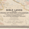
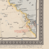
This Kharita™ was issued in 1946 by the National geographic magazine, v. 90, no. 6. It Includes numerous historical notes covering events from earliest times to the present.
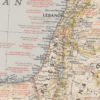
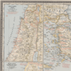
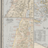
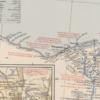
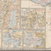
6 inset maps are displayed on the right hand side of the map, with the titles of:
- Holy Land today
- Holy Land in Biblical times from Dan to Beersheba
- Jerusalem
- Traditional route of the Exodus
- St. Paul’s travels and the seven churches.
- The crusades
It is worth mentioning that there is no mention of the state of Israel anywhere on this map as Israel was only officially recognized in 1948-two years after this map was issued.
Map Info
Creator: National Geographic Society (U.S.). Cartographic Division
Date: 1946
Language(s): English
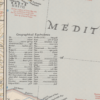
Scale: 1:4000000
Location: Middle East
✪ Heavyweight matte paper at 150 g/sqm
✪ Frame not included
✪ Package comes with shipping tube
NOTICE: International Shipping Temporarily On Hold.
After you place an order, you will receive an email confirming that we have received your order and are processing it. Orders usually take 2–12 business days to arrive.
We do not offer refunds on our maps as they are printed per order. You may request an exchange within 30 days if the item is in good condition.
Visit our Shipping & Returns page for more details.
 Skip to content