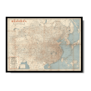
This rare Kharita™ is a celebration of the voyage of the ‘Nippon’, which made the first Japanese aerial circumnavigation of the World; conducted in the late summer-autumn of 1939, just as World War II had commenced, the ill-timed ‘Peace Tour’ was nevertheless impressive, as the 55-day-long 50,000 km+ trip was the longest airplane itinerary to date, highlighting the newly great prowess of Japanese aviation. In the late 1930s, Japan was brimming with confidence, a macho militaristic power which had cowed all its rivals in East Asia, and now felt ready to take on the world. It was especially proud of its new prowess in aviation, as in only a few years Japan’s airplane industry had gone from an embryonic joke to rivalling that of the best American and European manufacturers.
To create a worthy global PR spectacle, in 1939, a group of private investors led the by the Mainichi Shinbun newspaper group, decided to sponsor the first Japanese aerial circumnavigation of the world. While not a new concept (the first aerial circumnavigation was accomplished in 1924), this enterprise was to be unprecedented in scope and ambition. The group commissioned a Mitsubishi G3M2-Model 21 bomber plane, owned by the Mainichi firm, but removed the ordnance to allow it to fly steady and far. The craft was renamed the Nippon, and the goal was not to pursue the fastest route around the world, but rather to conduct a world ‘peace tour’, visiting as many countries as reasonably possible, promoting Japan and its supposed goodwill to all. The retrofitted Nippon was to carry seven crew and was to have a top speed of 375 km/h, a maximum range of 4,400 km, and an ability to fly for 24 hours without refueling The present beautifully designed and brightly coloured map charts the Nippon’s route. The voyage commenced at Tokyo’s Haneda Airport on August 23, 1939, and it lasted 55 days, including 194 hours of flying time, covering a total route 52,867 km, making it the longest aerial itinerary ever completed to date. The endeavour successfully concluded in Tokyo on October 20, 1939. The map shows the flight’s tracks with a bold line, labelling each of the stops along the way, in the 24 different lands visited marked with the flag of the appropriate country/colony, while a large image of the Nippon looms over the scene. As shown, the Nippon’s major stops included Tokyo – Chitose – Nome (Alaska) – Whitehorse (Yukon) – Seattle – Oakland – Los Angeles – St. Louis – New York – Washington, D.C – Miami – San Salvador, El Salvador – Quito – Lima – Arica (Chile) – Santiago – Buenos Aires – Santos (Brazil) – Rio de Janeiro – Recife – Dakar – Casablanca – Seville – Paris – London – Berlin – Rome – Basra (Iraq) – Karachi – Calcutta – Bangkok – Taipei – and Tokyo.
In the bottom of the map, a box features a description of the voyage, while to the left are portraits and brief resumes of the Nippon’s seven crew members, including Sumitoshi Naka (中尾純利), the Captain; Hajime Shimokawa (下川一), flight engineer; Nobusada Sato (佐藤信貞), communications operator; Shigeo Yoshida (吉田重雄), pilot; Hiroshi Saeki (佐伯), professional engineer; Nagasaku Yaokawa (八尾川長作), flight engineer; and Takeo Ohara (大原武夫), the Aerial Director of Mainichi Shimbun and the mission’s ‘Ambassador of Goodwill’. While the Nippon’s mission was hailed as great success, Nakao and his men lauded as national heroes, and its technical achievements inarguably impressive, the voyage’s timing as a ‘peace mission’ proved unfortunate. World War II in Europe commenced on September 1, 1939, and the Nippon was only able to fly across the airspace of the opposing powers due to Japan’s neutrality (Japan would not join the Axis Powers until September 1940 and would not actively join the war against the Allies until December 1941). Thus, while the Nippon’s crew were greeted cordially everywhere, nobody was in a ‘peaceful’ mood. Nevertheless, the Nippon’s exploits represented a major achievement in the history of global aviation. (Alexander Johnson and Dasa Pahor, 2022)
Map Info
Creator: Tokyo Nichinichi Shinbunsha
Date: 1939
Language(s): English
Scale: –
Location: World
✪ Heavyweight matte paper at 150 g/sqm
✪ Frame not included
✪ Package comes with shipping tube
NOTICE: International Shipping Temporarily On Hold.
After you place an order, you will receive an email confirming that we have received your order and are processing it. Orders usually take 2–12 business days to arrive.
We do not offer refunds on our maps as they are printed per order. You may request an exchange within 30 days if the item is in good condition.
Visit our Shipping & Returns page for more details.