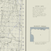
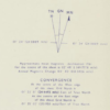
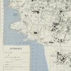
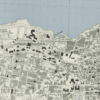
This Kharita™ is a Town plan of Beirut, Lebanon showing municipal boundaries, transportation, public, religious buildings, built-up areas, water features and vegetation. It was created by the Great British War Office in 1961. It also includes a reliability diagram and a history note.
Map Info
Creator: Great British War Office
Date: 1961
Language(s): English
Scale: 1:7500
Location: Beirut, Lebanon
✪ Heavyweight matte paper at 150 g/sqm
✪ Frame not included
✪ Package comes with shipping tube
NOTICE: International Shipping Temporarily On Hold.
After you place an order, you will receive an email confirming that we have received your order and are processing it. Orders usually take 2–12 business days to arrive.
We do not offer refunds on our maps as they are printed per order. You may request an exchange within 30 days if the item is in good condition.
Visit our Shipping & Returns page for more details.
 Skip to content