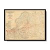
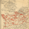
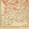
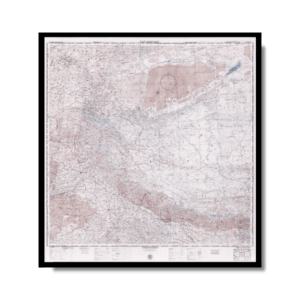
This ‘classified’ Kharita™ showcasing the major transport routes for thousands of Nazi armored vehicles and tanks, plus the locations of Wehrmacht gas stations, oil storage depots and garages across the entire European battle theatre, made during the height of ‘Operation Barbarossa’, Germany’s attempt to mount a ‘blitzkrieg’ invasion of Soviet Europe. The map was made for the Organisation Todt (OT), the massive joint governmental-corporate enterprise that was responsible for all aspects of Nazi Germany’s military-industrial complex. Petroleum, and easy access to it, for tanks and armored vehicles were key factors behind the Wehrmacht’s early success in World War II. The OT ensured that transport routes were always well maintained, while refueling and repair facilities were located at the right places to ensure that military traffic could maximize its progress. The transport-fuel distribution network proved its value during the Nazi ‘Blitzkrieg’ invasion of France and the Low Countries in May-June 1940, when German tanks and vehicles literally rolled over hundreds of kilometers enemy territory in only a matter of days, as well as the early period of the Operation Barbarossa. The map’s geographic scope extends from the tip of Brittany, in the west, all the way east across Europe, to the Urals (the gateway to Asia), and from the northern tip of Norway down to the middle Balkans, in the south. The ‘Zeichenenerklärung’ [Explanation of Symbols], below the title, upper right, provides the symbols employed to identify the key features of the transport-fuel distribution system.
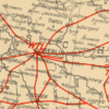
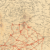
The core of the transport-fuel deployment system was in Germany itself, with its incredibly well-developed autobahn network, featuring the world’s first modern expressways, along with numerous oil refineries, stations and depots. The Nazi’s network is then shown to extend to the west, with an especially intense concentration of oil and tank/vehicle repair facilities in northern France and Belgium, which were both a legacy of the Wehrmacht’s blitzkrieg conquest of those lands, as well as Germany’s ongoing imperative to defend the English Channel coasts from possible British invasion. Notably, the map extends the network eastward, through occupied Poland and deep into the USSR. On June 22, 1941, only little over four months before the present map was made, the Wehrmacht mounted a massive blitzkrieg invasion of Russia and Ukraine. While the Nazis failed to take Leningrad (with would be besieged for 872 days before the Germans were driven off), their tanks and armoured vehicles rumbled over the Eastern European Plains. By the beginning of November 1941, the Germans were only 87 km from Moscow and had taken the western half of Ukraine. While their progress was, impressive, the vast distances involved and the onset of the Russian winter began to severely test the Organisation Todt’s supply chains, which came to experience their first broken links. Indeed, as future events proved, the Nazis overextended themselves in Russia, and fortunately for the world, this would ultimately lead the fall of the Third Reich.
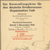
The map was considered to be highly sensitive and bears the note ‘Nur für den Dienstgebrauch!’ [For official use only!] and would have been issued in only a very small print run for the exclusive use of select, authorized personnel.
 Skip to content