
 (1)")


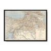
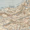
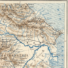
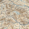
Created in 1919 by Zatik (Zadig) H. Khanzadian, this historic Kharita offers a clear and detailed representation of Armenia and its surrounding regions at a pivotal moment in modern history. It was formally presented by the Armenian National Delegation during the Paris Peace Conference, where the future of many post-war borders was being negotiated.
Drafted in the aftermath of World War I and the Armenian Genocide, the map reflects the Armenian national movement’s push for recognition and sovereignty. It illustrates both the modern-day Armenian territory and the historical Armenian lands that were central to diplomatic claims at the conference.
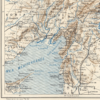
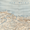
Produced in color, with clear distinctions between administrative districts, provinces, and historical borders. Shows church centers, railroad lines, towns, rivers, and mountain ranges through contour lines and shading. Contains a clear legend and standardized cartographic symbols typical of early 20th-century mapmaking.
This map was created as a political and historical document. Khanzadian, an experienced cartographer and naval officer, designed it to support the Armenian delegation’s territorial claims and to inform Western policymakers of Armenia’s geography and heritage. It served as an important reference during the diplomatic discussions that led to the Treaty of Sèvres (1920), even though its outcomes were later overturned by shifting geopolitics.
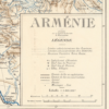
Map Info
Creator: Zatik H. Khanzadian
Date: 1919
Language(s): French
Scale: 1:1,800,000
Location: Armenia