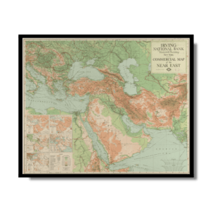
This Italian Kharita™ illustrates the distribution of religious affiliation in the Muslim populations of the Middle East. It shows the locations of adherents to the four schools of Sunni belief and the distribution of Shia populations. Where it is impossible to portray this diversity visually, the sheet provides a few paragraphs of further explanation, such as on the Senussi order in Medina, the Maliki school of Islamic law in Syria, and the Hanafi school as the official law of the Ottoman provinces.
The map is rich in detail, and shows a profusion of small towns and villages. Deserts or areas “of low culture” such as the Arabian Desert, the Sinai, and the Eastern Desert of Egypt are shown as white space. Information on the map is given as of September 1918. The map covers the area from Homs (Syria) and Chermansciah (present-day Kemanshah, Iran) in the north to the entire Arabian Peninsula in the south and east. The map was created by the prolific Italian cartographer Achille Dardano (1870-1938) and annotated by Carlo Alfonso Nollini (1872-1938), a scholar who was at one time the professor of famous Egyptian writer Taha Hussein. The map was photolithographed by the Italian Ministry of Colonies.
Map Info
Creator: Nollini, Carlo Alfonso, Dardano, A. (Achille)
Date: 1918
Language(s): French
Scale: 1:6,000,000
Location: Arabian Peninsula
✪ Heavyweight matte paper at 150 g/sqm
✪ Frame not included
✪ Package comes with shipping tube
NOTICE: International Shipping Temporarily On Hold.
After you place an order, you will receive an email confirming that we have received your order and are processing it. Orders usually take 2–12 business days to arrive.
We do not offer refunds on our maps as they are printed per order. You may request an exchange within 30 days if the item is in good condition.
Visit our Shipping & Returns page for more details.