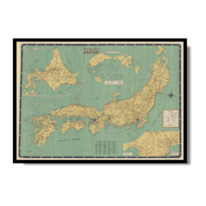
This highly significant Kharita, titled “Japanischen Reiche” or Japanese Empire is considered one of the first modern maps of Japan printed in the Western world, based upon information obtained by Siebold during his travels in Japan, primarily the groudbreaking surveys made by the Japanese cartographer Ino Tadataka. It represents a radical improvment over all previous maps of Japan, and was by far the most accurate impression of the islands available during the opening of Japan to Westerners, following the visit of American Commodore Matthew C. Parry in 1854.
The main map embraces most of Honshu and all of Shikoku and Kyushu. Hokkaido, referred to as “Jezo”, is essentially absent, for it had not yet been properly mapped. Insets include the northern tip of Honshu (in the upper left) and a detailed sea chart of the Harbor of Nagasaki (in the lower right), which was the only port in Japan then open to western commerce. Overall, the geography is shockingly modern and accurate, especially in comparison to earlier maps of the islands. Due to the Japanese Shogunate’s longtime restrictions on foreign visitation to the country, Japan was one of the last heavily populated regions of East Asia to be comprehensively mapped by westerners. Siebold’s work thus represents a major milestone. Great care is taken to label the locations of mountains, roads, prefectural boundaries, and towns. Siebold, who was a keen ethnographer, even provides a table translating Japanese geographical terms into German (along the right side of the map). One interesting feature of the map is the inclusion of the island of “Argonaut”, a mis-identification of the Korean island of Ulleungdo.
It was Siebold’s interest in cartography that led to the so-called “Siebold Incident”, which resulted in his expulsion from Japan. While the Japanese authorities seemed tolerant, if not a little bemused, by Siebold’s endeavors to collect natural specimens, this indulgence had its limitations. In 1829, when officials accidentally discovered Siebold’s map collection, they were aghast that a foreigner possessed sources that contained such accurate and detailed geographical intelligence and military information. Accusing him of being a Russian spy, they placed him under house arrest, before expelling him from the country. Surprisingly, the Japanese authorities did not confiscate all of Siebold’s maps, allowing him to take them back to Europe. Upon Siebold’s return to Europe in 1830, he settled in the Dutch university town of Leiden. He soon opened a magnificent museum for his specimen collection, and set to work on his monumental publication of Nippon, a project that would last 20 years. During this period he carefully prepared finished manuscript maps, in preparation for them to be lithographed.” (Ruderman, 2020)
Map Info
Creator: Siebold, Phillip Franz von
Date: 1840
Language(s): German
Scale: –
Location: Japan
✪ Heavyweight matte paper at 150 g/sqm
✪ Frame not included
✪ Package comes with shipping tube
NOTICE: International Shipping Temporarily On Hold.
After you place an order, you will receive an email confirming that we have received your order and are processing it. Orders usually take 2–12 business days to arrive.
We do not offer refunds on our maps as they are printed per order. You may request an exchange within 30 days if the item is in good condition.
Visit our Shipping & Returns page for more details.


![Pictorial Map of Wildlife in the USSR 1941 [Set of 2]](https://mykharita.com/wp-content/uploads/2024/03/83-2-300x300.png)