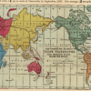
This spectacular Kharita™ is an infographic created to celebrate the technology of the submarine telegraph and the laying of the second Transatlantic Cable in 1866 which was a great technological achievement. The infographic goes into great detail on the history and process of the telegraph and includes 2 inset maps showing the telegraph lines.
After a number of failed attempts, in early August 1858 Cyrus Field’s Atlantic Telegraph Company finished laying the first transatlantic cable between Ireland’s Valencia Bay and Trinity Bay in Newfoundland. The first official transatlantic telegraph messages were exchanged by President Buchanan and Queen Victoria on the 16th, touching off celebrations on both sides of the Atlantic, though the cable failed within a matter of weeks. It was not until July 1865 that Field was able to launch an attempt to lay a replacement cable, and this too failed on July 31 after the cable parted and was lost. In September 1866 yet another expedition, organized by the newly-formed Anglo-American Telegraph Company, succeeded in laying a new cable and recovering, repairing and installing the one lost the previous year. There were now two transatlantic cables in operation, and their improved design yielded dramatic improvements in speed and capacity relative to the short-lived cable of 1858. Field was hailed as a visionary, with one writer describing him as “the Angel in the Book Revelation with one foot on sea and one foot on land, proclaiming Time is no longer.”
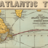
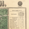
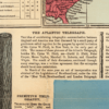
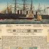
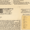
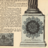
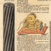
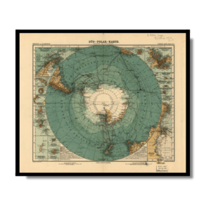
It is hard to overstate the impact of the cables, which prompted a flood of text and imagery in the popular media. Offered here is a fine example of the genre, being an extremely rare map published in London and New York while the 1866 Anglo-American Telegraph Company expedition was in progress. The map features long text passages summarizing the history of attempts to lay a transatlantic cable, explaining the technology, and describing the Atlantic Telegraph Company’s ongoing expedition. The profusion of graphics includes a map of Europe, Africa and America showing the routes of existing and projected submarine cables; another map, showing a projected telegraph route around the world; a large central view and a cutaway of the Great Eastern, which laid the cable; and diagrams illustrating the differences between the cables of 1858, 1865 and 1866. A statistical chart flanking the map at top lists existing submarine telegraphs and their termini, lengths, capacity and years in service.
Map Info
Creator: Bacon & Co.
Date: 1865
Language(s): English
Scale: –
Location: World
✪ Heavyweight matte paper at 150 g/sqm
✪ Frame not included
✪ Package comes with shipping tube
NOTICE: International Shipping Temporarily On Hold.
After you place an order, you will receive an email confirming that we have received your order and are processing it. Orders usually take 2–12 business days to arrive.
We do not offer refunds on our maps as they are printed per order. You may request an exchange within 30 days if the item is in good condition.
Visit our Shipping & Returns page for more details.
 Skip to content